expr:class='"loading" + data:blog.mobileClass'>

Friday, June 10, 2016

Southern California rocked by 5.2 earthquake


Southern California rocked by 5.2 earthquake

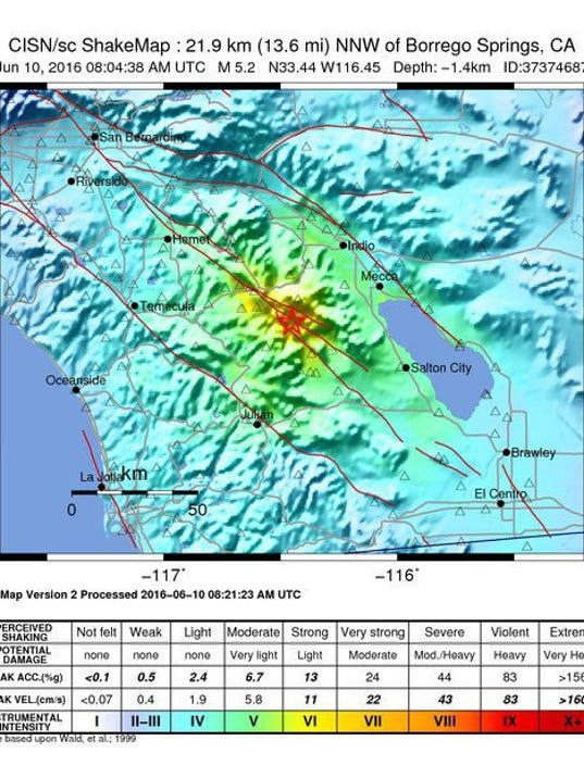
A handout shakemap released by the US Geological Survey (USGS)(Photo: USGS, EPA)

LOS ANGELES -- An moderate earthquake with a preliminary magnitude of 5.2 rocked Southern California, rousing residents out of bed at about 1:05 a.m. PT.

The quake was centered near Borrego Springs in the desert east of Los Angeles, the U.S. Geological Service reported.

On the west side of Los Angeles, about 100 miles from the epicenter, the quake produced a long shaking motion lasting about 30 seconds. There was no hard jolt. In USA TODAY's news bureau on the ninth floor of an office building near Los Angeles International Airport, window shutters shook and the building structure rolled in steady waves.

The quake was also felt in San Diego.

Seismologist Lucy Jones tweeted that quake struck on the San Jacinto fault, one of the most active in the region. She says the same fault produced a magnitude 6 earthquake in 1937 and a 5.3 quake in 1980.

source: usatoday

Tuesday, June 7, 2016

Tropical Storm Warnings


Tropical Storm Warnings Dropped on Part of Coast.

Tropical Storm Colin continues to move away from the southeastern coast of the United States, but not before dumping heavy rain along North Carolina's Outer Banks.

The National Weather Service dropped a tropical storm warning for northern Georgia, South Carolina and the southeastern coast of North Carolina at 8 a.m. Tuesday.

But the warning continues in part of North Carolina, from just north of Wilmington to Oregon Inlet, which is just south of Nags Head on the Outer Banks.

Forecasters say up to another 3 inches of rain could fall along the Outer Banks. Wind gusts of up to 50 mph are still possible.

Schools in Wilmington were opening two hours later than usual.

Duke Energy reported just a handful of customers without service in eastern North Carolina.

Some cities in Florida got 9 inches of rain during Tropical Storm Colin.

The National Weather Service said Tuesday that parts of Pinellas County, along Florida's Gulf Coast, got that much rain. Other areas, from Levy to Sarasota counties, were also soaked with 1 to 6 inches of rain in a 24-hour period.

Flood warnings were issued in many parts of the Tampa Bay area and Tuesday's commute was shaping up to be a difficult one with roads underwater and in some areas, closed entirely. Rain fell steadily in the Tampa-St. Petersburg area overnight.

Storms are expected to continue through the afternoon.

Susie Morris, the proprietor of the Lighthouse Inn Bed & Breakfast on Georgia's Tybee Island, said she awoke Tuesday to no wind and no rain.

Morris said that to her relief, Tropical Storm Colin had not flooded the inn, a restored 1910 home.

The National Hurricane Center said Colin marked the earliest that a third named storm has ever formed in the Atlantic basin. Morris said she's not worried about the early start to the 2016 hurricane season, but will continue to listen to weather reports and take precautions when needed.

Forecasters expect Tropical Storm Colin's forward progress to speed up during the day Tuesday as it chugs along the southeast coast, most likely just off shore.

Jack Beven, senior hurricane specialist at the National Hurricane Center, said the storm was moving at 31 mph early Tuesday morning, and was expected to move even faster later in the day.

Beven said the storm's track will be roughly parallel to the U.S. coast as it moves northeast near the South Carolina and North Carolina coast.

Beven said there's a chance for 1 to 3 inches of rain in parts of the Carolinas.

Tropical Storm Colin seems to be bypassing South Carolina.

No rain was reported early Tuesday across the state, although earlier rain has brought the usual street flooding in downtown Charleston.

The National Weather Service still has a tropical storm warning in effect for the entire coast, although winds are expected to be only around 15 to 25 mph, with occasional gusts up to 35 mph. Forecasters say no additional rain is expected.

No injuries have been reported.

Transportation Department officials say parts of nine roads are closed, six in Charleston County and three in Jasper County.

South Carolina Electric & Gas reported 72 customers without service Tuesday morning. Jasper County had the biggest problem with about three dozen customers without service.

Duke Energy reported only a handful of customers without service.

Meanwhile, Jack Beven, a senior hurricane specialist, at the U.S. National Hurricane Center, says 1 to 3 inches of rain are possible along the coast of North Carolina.
The U.S. National Hurricane Center says Tropical Storm Colin's center is moving into the Atlantic east of the Georgia coast.

The storm's maximum sustained winds Tuesday morning are near 50 mph (85 kph). Some strengthening is expected, but the storm is forecast to lose its tropical cyclone status by Tuesday night.

As of 5 a.m. EDT, Colin was centered about 90 miles (145 kilometers) south-southwest of Charleston, South Carolina, and moving northeast near 31 mph (50 kph).

Colin is expected to produce 3 to 6 inches of rain across western to northern Florida, southeast Georgia and coast areas of the Carolinas through Tuesday. Isolated areas could see up to 10 inches.

Also, tornadoes will be a possibility across parts of the coastal Carolinas on Tuesday.
The National Weather Service says Tropical Storm Colin has made landfall and is bringing high winds and heavy rain to northern Florida.

The weather service says the center of the storm was located about 55 miles (90 kilometers) west-southwest of Jacksonville early Tuesday morning.

It says the storm's maximum sustained winds were around 50 mph (85 kph) with higher gusts and it is moving to the northeast at 23 mph (37 kph).

It is expected to continue moving in that direction at a faster speed over the next 48 hours.

Colin is expected to produce 3 to 6 inches of rain across western to northern Florida, southeast Georgia and coast areas of the Carolinas through Tuesday. Isolated areas could see up to 10 inches.

source: abcnews

Sunday, June 5, 2016

East Coast on alert as Tropical Storm Colin forms


East Coast on alert as Tropical Storm Colin forms, severe storm front moves through.

Much of Florida's western coast was placed under a tropical storm warning Sunday as Tropical Storm Colin formed in the Gulf of Mexico, as a separate storm system brought severe weather and damaging winds to the Mid-Atlantic region.

Colin is on course to hit Florida as soon as Monday, according to the National Hurricane Center, which warned the storm could cause serious flooding along much of the state's Gulf coast.

The center added the quickly moving storm is the earliest a third named storm has ever formed in the Atlantic basin.

The storm was moving at a speed of about 12 mph, and was expected to pick up the pace later Sunday.

"It's going to impact most of the state in some way," Gov. Rick Scott told the Associated Press. "Hopefully we won't have any significant issues here, but we can have some storm surge, some rain, tornados and some flooding."

Scott postponed a political meeting with presumptive Republican presidential nominee Donald Trump scheduled Monday in New York so he can remain in the state capital to monitor the weather.

Tropical storms carry wind speeds of between 39 mph and 73 mph.

Tropical Storm Colin is likely to bring dangerous rainfall levels, and residents were warned about possible flooding and hazardous driving conditions. Rain began falling in the Tampa Bay area just past noon on Sunday.

Scott warned residents not to simply look at the center of the storm, saying the heaviest rain will be to the east and west of it.

Several counties in the Tampa Bay area made sandbags available throughout the weekend for residents to prepare for potential flooding, Fox 13 reported.

"We're surrounded on three sides by water," said Pinellas County spokesman Nick Zoller, who said the county distributed 3,300 sand bags on Saturday, a number he expected to go up now that a tropical storm warning is in effect.

Just to the north, Pasco County Emergency Services Director Kevin Guthrie said the message is to be prepared.

"We are going to flood in parts of Pasco County," Guthrie said in an email.

After affecting the Gulf coast of Florida, the Colin is forecast to move northeast. The Georgia coast and the north Florida Atlantic coast were placed under a tropical storm watch Sunday evening.


Colin is the latest in a series of severe whether events across the country, from record-breaking heat in the West, flooding in Texas and storms that are expected to cause problems in the nation's capital and mid-Atlantic region.

The National Weather Service warned of an "enhanced" risk of severe storms in the mid-Atlantic region with the possibility of damaging winds.

Sterling, Virginia-based meteorologist Chris Strong said the primary threat in the Baltimore-Washington metropolitan area is from damaging wind gusts, and there's a lesser threat for tornados.

Wakefield, Virginia-based meteorologist Lyle Alexander says the threat on the Eastern Shore is from winds and more localized heavy rain.

The weather service warns that heavy rain in central Virginia and the Shenandoah Valley could mean flooding in areas that received rain Saturday. Flash flood watches are in effect until evening.

Mount Holly, New Jersey-based meteorologist Lance Franck says in Delaware the threat is from high winds and torrential downpours bringing flooding to urban areas and areas with poor drainage.

In New York City, the last day of a music festival that was to include performances by Kanye West and Death Cab for Cutie was canceled because of weather concerns.

The heavy rain that's been hovering over parts of Southeast and Central Texas and caused deadly flooding began to lift Saturday, but officials said the flooding emergency near the Gulf Coast was worsening and Army officials kept up their investigation of a training exercise that turned deadly at Fort Hood.

In Southeast Texas, water levels began to recede Saturday along upstream portions of the Brazos River, but the peril increased downstream as the water churned toward the Gulf of Mexico.

Emergency officials in Brazoria County warned residents in East Columbia, Bailey's Prairie and Bar-X to be prepared to evacuate their homes.

Except for widely scattered showers in Central and East Texas, the bulk of the rain Saturday was confined to the upper Texas Gulf Coast and the southern tip of Texas.

In Fort Bend County, just southwest of Houston, emergency officials reported seeing slightly improved conditions in flood-struck areas. And while the rain-swollen Brazos has ceased to rise, County Judge Robert Hebert said, some neighborhoods remain cut off by floodwaters and many local streets remain impassable.

source: foxnews

Thursday, June 2, 2016

Heavy Rains Cause Floods in France and Kill 9 in Germany


Heavy Rains Cause Floods in France and Kill 9 in Germany


PARIS — Torrential rains have caused major flooding in central and northeastern France this week, forcing the evacuation of thousands of people, some on boats or kayaks, and threatening priceless works of art stored in Paris’s most celebrated museums. In Germany, heavy rains claimed the lives of nine people.

In Paris, the Seine rose 16 feet above its typical level, flooding the lower embankments and shutting several roads but causing no significant damage. The level is still far from the record of 1910, however, when the river rose 26 feet above its regular level.

Nonetheless, the city authorities advised people to stay away from the banks of the river and part of Paris’s commuter train system that runs below ground along the Seine was shut as a preventive measure.

The Louvre announced that it would be closed on Friday to move, as a precautionary measure, works of art in areas vulnerable to flooding.

The Musée d’Orsay, in a former train station on the Left Bank near the Seine, closed early to put in place a flood-protection plan that calls for swift evacuation of the museum’s Impressionist masterpieces and other works of art in the event of flooding.

The rainfall also disrupted the French Open, where several tennis matches have been postponed.

Officials in France and Germany were bracing for even more rainfall this week. The Loing River, a tributary of the Seine, has risen to levels not seen since 1910, and the Île-de-France region, which includes Paris, got more rainfall last month than in any May since 1960.
Inundated streets in Simbach am Inn, southern Germany, on Thursday.

President François Hollande said Thursday that the rainfall and floods were “very serious,” and linked them to global warming.

“When there are climatic phenomena of this seriousness, we must all be aware that we must act globally,” he said. He later added that the government would declare a state of disaster for affected areas, enabling residents and businesses to receive special insurance compensation. About 20,000 homes in France had lost power and an estimated 5,000 people had to be evacuated.

Meteorologists attribute the recent deluge to a dip in the jestsream that has trapped low-pressure air over much of France and Germany, where the air is then warmed by the sun. This occurrence often leads to heat waves, and to thunderstorms as the hot air rises.

The recent thunderstorms have been more intense than usual because the hot air rises to encounter colder air in the upper atmosphere. Generally, the greater the difference between the rising hot air and the colder high air, the bigger the storms.

Forecasters say there could be a few more days of rain before the low-pressure air finally moves on.

Speaking from the government’s crisis center in Paris on Thursday, Prime Minister Manuel Valls said that the situation was still “tense” and “difficult” in certain areas.

More than 3,000 people were evacuated from Nemours, about 50 miles south of Paris, after the Loing overflowed, flooding businesses and homes. The surrounding Seine-et-Marne area was on high alert for floods on Thursday, and 12 other administrative departments in the Île-de-France and Centre-Val de Loire regions were on the second-highest level of flood alert.

Traffic around Orléans, about 75 miles south of Paris, was blocked, and on Tuesday, 217 inmates had to be evacuated from a prison near Orléans. The Château de Chambord, a landmark in the Loire Valley, about 30 miles southwest of Orléans, was surrounded by water.

In Germany, the rains have claimed nine lives.


On Monday, in the southwestern state of Baden-Württemberg, two people, including a firefighter, were sucked into a drainpipe in the town of Schwäbisch Gmünd; a 62-year-old man was found dead in a flooded basement garage in Weissbach; and a 13-year-old girl, seeking shelter under a railway bridge, was struck by a train and killed in Schorndorf.

On Thursday, five people were found dead in the southern German state of Bavaria. They included three women from one family, in a home in the town of Simbach am Inn; a 75-year-old man in the same town; and an 80-year-old woman in the neighboring village of Julbach.

Three others were missing, and the death toll could rise, Michael Emmer, a spokesman for the police in the Lower Bavaria region, told the German news agency DPA.

Interior Minister Joachim Herrmann said the intensity of the flooding had taken officials by surprise. “Within a few minutes, the water level rose about several meters,” he said.

Officials said they were preparing for additional storms and strong rains in western and southern Germany. At a news conference, Chancellor Angela Merkel expressed condolences to the families of the victims.

In the village of Bad Neuenahr-Ahrweiler in the state of Rhineland-Palatinate, the Ahr River rose nearly 13 feet to a level that officials said was unprecedented. Several campers in the region sought refuge on the roofs of vehicles and were rescued by helicopter.

In the nearby Eifel mountain range, which is popular with tourists and hikers, flooding was also reported.

Thousands of homes in Bavaria were without power, officials said.

source: nytimes
Wednesday, June 1, 2016

Extreme Weather May Raise


Extreme Weather May Raise Toxin Levels in Food, Scientists Warn

U.N. report says wheat and other crops generate potential toxins to protect themselves from intense weather


NAIROBI, May 31 (Thomson Reuters Foundation) - As they struggle to deal with more extreme weather, a range of food crops are generating more of chemical compounds that can cause health problems for people and livestock who eat them, scientists have warned.
A new report by the United Nations Environment Programme (UNEP) says that crops such as wheat and maize are generating more potential toxins as a reaction to protect themselves from extreme weather.
But these chemical compounds are harmful to people and animals if consumed for a prolonged period of time, according to a report released during a United Nations Environment Assembly meeting in Nairobi.
"Crops are responding to drought conditions and increases in temperature just like humans do when faced with a stressful situation," explained Jacqueline McGlade, chief scientist and director of the Division of Early Warning and Assessment at UNEP.
Under normal conditions, for instance, plants convert nitrates they absorb into nutritious amino acids and proteins. But prolonged drought slows or prevents this conversion, leading to more potentially problematic nitrate accumulating in the plant, the report said.
If people eat too much nitrate in their diets, it can interfere with the ability of red blood cells to transport oxygen in the body, the report said.
Crops susceptible to accumulating too much nitrate in times of stress include maize, wheat, barley, soybeans, millet and sorghum, it said.


DROUGHT, THEN RAIN


Some drought-stressed crops, when then exposed to sudden large amounts of rain that lead to rapid growth, in turn accumulate hydrogen cyanide, more commonly known as prussic acid, the report said.
Prussic acid - one of the ingredients used in some types of chemical warfare - interferes with oxygen flow in humans. Even short-term exposure can be debilitating for people, McGlade said.
Plants such as cassava, flax, maize and sorghum are most vulnerable to dangerous prussic acid accumulation, the report said.
Cases of nitrate or hydrogen cyanide poisoning in humans were reported in Kenya in 2013 and in the Philippines in 2005, McGlade said. In Kenya, two children died in coastal Kilifi after eating cassava that had raised levels of prussic acid in it following extreme rainfall, according to local media reports.
Aflatoxins, molds that can affect plant crops and raise the risk of liver damage, cancer and blindness, as well as stunting foetuses and infants, also are spreading to more areas as a result of shifting weather patterns as a result of climate change, scientists said.
McGlade said about 4.5 billion people in developing countries are exposed to aflatoxins each year, though the amounts are largely unmonitored, and the numbers are rising.
"We are just beginning to recognise the magnitude of toxin- related issues confronting farmers in developing countries of the tropics and sub-tropics," the report noted.
"As warmer climate zones expand towards the poles, countries in more temperate regions are facing new threats," it added.
In 2004, Kenya suffered severe outbreaks of aflatoxin poisoning, which affected more than 300 people and killed more than 100 following a prolonged drought, according to the International Livestock Research Institute.

EUROPE AT RISK


The UNEP report said Europe will be at growing risk from aflatoxins in locally grown crops if global temperatures rise by at least 2 degrees Celsius. The world is currently on a path to a more than 3 degree Celsius temperature rise, scientists believe.
An increase in toxic compounds in crops is likely to impact heavily on the world's health system, which are already struggling with the effects of food insecurity, Dorota Jarosinska of the World Health Organization's European Center for Environment and Health said in an interview with the Thomson Reuters Foundation.
Alex Ezeh, executive director of the African Population Health and Research Center, said the increase in toxins in crops was a big concern.
"Toxic crops can lead to neurological diseases among humans but the greatest challenge is the incidence of cancer," he said in an interview.
The report proposes a list of eight ideas farmers and agricultural experts can adopt to try to limit damage from more crop toxins, such as mapping contamination hotspots and building better evidence about what is happening now with the toxins in their area.
Scientists also suggest that developing crop varieties designed to cope with extreme weather could help reduce the levels of toxic chemicals in food.
"Research centers with the Consultative Group on International Agricultural Research are developing seeds that are suitable in various regions that have been hit by climate change," McGlade said.
(Reporting by Kagondu Njagi; editing by Laurie Goering :; Please credit the Thomson Reuters Foundation, the charitable arm of Thomson Reuters, that covers humanitarian news, climate change, women's rights, trafficking and property rights.

source: scientificamerican

Sunday, May 29, 2016

Tropical Storm Bonnie weakens to tropical depression


Tropical Storm Bonnie weakens to tropical depression as it approaches Ga., Carolina coasts

Track forecast for Tropical Storm Bonnie. (National Hurricane Center)

8:28 a.m. Sunday update: Bonnie has weakened from a tropical storm into a tropical depression as it pushes toward the Georgia and Carolina coastlines, the Associated Press reported.

There’s never a good time for a tropical storm, even a weak one. But most would agree Memorial Day weekend is particularly bad timing, especially those along the South Carolina coast, where a tropical storm warning is in effect ahead of heavy rain, somewhat strong winds, and a possible 1- to 2-foot storm surge.

Bonnie, the season’s second named storm, achieved tropical storm status late this afternoon. It is currently centered in the Atlantic Ocean about 135 miles south-southeast of Charleston, S.C. Maximum sustained winds of 40 mph have increased modestly since yesterday. Slight strengthening is possible overnight before gradual weakening on Sunday.

Satellite view of Tropical Storm Bonnie Saturday evening. (NOAA)

The storm is forecast to make landfall near Charleston, S.C. Sunday morning or afternoon. Heavy rains have already begun falling near the coast and moved towards South Carolina’s interior.

Because this is a relatively weak tropical storm, rain rather than wind or storm surge is considered the greatest hazard. That said, sustained winds over 30 mph are like along the South Carolina coast tonight, with the National Hurricane Center showing a 40 to 50 percent chance of tropical storm force winds (sustained at 39 mph or higher).

The system’s circulation, along with occasional showers and thunderstorms, may linger for several days along the South Carolina-North Carolina coast, gradually weakening through midweek.

The rain is expected to be heaviest in South Carolina overnight, before spreading northward into North Carolina and Virginia Sunday. Generally the storm is forecast to produce 1 to 3 inches of rain near its core, with locally up to 5 inches.

Northern Virginia, the District, Maryland and Delaware get in on the rain late Sunday afternoon into Monday, with up to about 1 to 2 inches possible in many spots as tropical moisture surges northward far from the core of the system.

Rainfall forecast through 8 p.m. Monday night. (NWS)

D.C. area impacts


In the D.C. area, moisture streaming out ahead of the system brings a slight (20-30 percent) chance of showers Sunday afternoon. But most of the rain probably holds off until evening (starting between 5 and 10 p.m. from southwest to northeast), keeping much of the daylight hours dry.

The period of heaviest rain is likely to occur between Sunday night after dark and early Memorial Day.

The band of heaviest rainfall, which could be generally up to about 2 inches with locally higher amounts, could be narrow and is thus hard to pinpoint. Below are model rainfall amount forecasts.

The GFS model shows the band of heaviest rain (1 to 3 inches) just west of D.C. and Interstate 95, with lighter amounts to the east …

GFS total rainfall forecast through Monday morning. (StormVistaWxModels.com)

The European model suggests 1 to 2 inches of rain across the area through Monday afternoon, with a tendency for the heaviest rainfall along and east of I-95 …

Rainfall forecast by European model between Sunday and Monday night. (StormVistaWxModels.com)

The NAM model shows lighter amounts for the D.C. area, generally 0.25 to 0.75 inches, with 1 to 3 inches+ totals confined to lower Southern Maryland and parts of eastern Virginia …

NAM total rainfall forecast through Monday afternoon. (StormVistaWxModels.com)

While a chance of showers may linger through the day on Monday, it now seems likely that the steady soaking rain exits the area by mid- to late-morning. So don’t cancel that Memorial Day barbecue quite yet. Although rain probably continues later in the day at the beaches.


source: washington post

Friday, May 27, 2016

2016 Asia summer forecast: Drought to ease in India; La Nina to suppress typhoons in West Pacific


2016 Asia summer forecast: Drought to ease in India; La Nina to suppress typhoons in West Pacific.

This summer, the pattern responsible for extensive drought and heat in southeastern Asia will break down enough to bring relief to some nations. Meanwhile, the tropics will spring to life for a time.
Rainfall from the southwest monsoon and the East Asia monsoon is forecast to be more robust this summer due to the weakening El Niño.

La Niña to develop by late summer

El Niño is defined by above-average sea-surface temperatures in the eastern and central equatorial Pacific Ocean. These sea-surface temperatures cycle from warm to cool, relative to average, over a several-year period. When the sea-surface temperatures in the same area of the Pacific Ocean are cooler than average for a few months, a La Niña pattern has developed.
"El Niño will transition to neutral conditions early this summer, then perhaps toward a weak La Nina during August or September," according to AccuWeather Chief International Meteorologist Jason Nicholls. "Because of this and other factors, we expect rainfall to return toward average over a large part of India, Malaysia and Indonesia."
The speed at which the cycle trends toward La Niña will contribute to the amount of rainfall.
"If El Niño conditions linger through much of the summer, average or less-than-average rainfall could still occur," Nicholls said. "Conversely, if La Niña conditions develop more quickly, then rainfall could trend to well above average in some areas."

Rain to ramp up in southeastern Asia, recur in part of Middle East

While the East Asia monsoon contributes to a significant amount of rain annually in southeastern China, the region could be significantly wetter than average.
"Rainfall could be excessive in part of the Yangtze River Valley with the possibility of flooding in agricultural and heavily populated areas," Nicholls said.
Rain will significantly ease drought and heat in portions of India, Malaysia and Indonesia.
"Routine pulses of thunderstorms meandering around the Indian Ocean basin could also produce excessive rainfall and the risk of flooding in parts of India," according to AccuWeather Meteorologist Adam Douty.
In the Middle East, higher-than-average Indian Ocean temperatures, especially in the Arabian Sea, have contributed to localized heavy rainfall since last fall.

Archive
In this Nov. 24, 2015 image released by the Saudi Press Agency, cars drive on a flooded street in Al-Qassim Region, west of Riyadh, Saudi Arabia. (Saudi Press Agency via AP)

"We expect this part of the Indian Ocean to slowly cool, relative to normal," Nicholls said. "This might be enough to tone down the number of heavy rain events in the southeastern part of the Arabian Peninsula as the summer progresses."
Until the sea-surface temperature anomaly diminishes, the potential for scattered heavy rainfall will continue over the southern part of the Arabian Peninsula well into the summer.

Stubborn areas of drought may persist

There are likely to be some areas where the rain struggles, despite the diminishing El Niño. With some exceptions, El Niño greatly suppressed rainfall over a large part of southern Asia since last summer.
An area where rainfall could remain significantly below average during the summer includes the central part of the Philippines to Vietnam, Cambodia, Laos, Thailand and southeastern Myanmar.
Much of this area has been experiencing its worst drought in decades. The drought has taken its toll on the water supply, agriculture and economies in the region.
Especially hard hit has been the center of rice production in Asia: the Mekong River Delta.
Archives
In this March 28, 2016 photo, Thai workers repair a dried up irrigation canal at Chai Nat province, Thailand. Much of Southeast Asia is suffering its worst drought in 20 or more years. Tens of millions of people in the region are affected by the low level of the Mekong, a rice bowl-sustaining river system that flows into Laos, Thailand, Cambodia and Vietnam. (AP Photo/Sakchai Lalit)

As of early May in India, "the combination of excessive heat and drought has decimated crops, killed livestock and left at least 330 million without enough water for their daily needs," according to the Associated Press.
"Heat and drought go hand in hand," AccuWeather Meteorologist Jim Andrews said. "Both typically occur before before the summer rain arrives, but what has been going on during March and April has been exceptional."
Multiple nations in Southeast Asia experienced their hottest temperatures on record for any day of the year during April.
The list of nations that have experienced all-time record highs include Thailand at 44.6 C (112.3 F), Cambodia at 42.6 C (108.7 F), Laos at 42.3 C (108.1 F) and the Maldives at 34.9 C (94.8 F).
On May 19, 2016, India reached its highest temperature ever recorded when the mercury rose to 51 C (123.8 F) in Rajasthan.
Where the rain develops and becomes more frequent, heat will throttle back.
From much of the balance of Saudi Arabia to the Black and Caspian seas, a drier- and hotter-than-average summer is forecast.
Average to slightly above-average warmth with generally average rainfall is in store from Kazakhstan, northern China, Mongolia, central and Far East Russia and North and South Korea.
Below-normal normal number of typhoons, tropical storms anticipated
In terms of tropical activity, a lower number of tropical storms and typhoons are anticipated, relative to last year and the long-term average.

Accuweather

Last year there were 27 named tropical systems, of which 18 were typhoons and eight became super typhoons.
Despite the lower numbers forecast for the entire year, the summer part of the tropical season could be more active than the fall, in terms of impacts to land areas.
"Prior to the anticipated La Niña and less-favorable conditions for tropical systems this fall, low wind shear and warm waters, relative to average, will favor strengthening and a significant number of tropical systems in the western Pacific for a time this summer," according to AccuWeather Tropical Expert Dan Kottlowski.
The threat of direct impact from a tropical storm or typhoon will shift northward over the western Pacific shoreline as steering winds change the track of prospective systems throughout the summer.
"Areas that could be hit through the middle of the summer include the northern part of the Philippines, Taiwan and China," Nicholls said. "Toward the latter part of the summer and into the fall, the main risk area will shift toward Japan."
Should La Niña fail to develop during the late summer and fall, the number of tropical storms and typhoons could be close to average. Should La Niña develop at a fast pace, the number of tropical systems in the western Pacific could be well below average.
In the Indian Ocean basin, the summer tropical threat will be mainly during the early part of the season, as usual.
"There is a risk of one or more strikes by a tropical cyclone over Bangladesh, northeastern and southern India and northern Myanmar, as well as part of northwestern India and perhaps Oman," Nicholls said.
The threat in the Bay of Bengal is in addition to Cyclone Roanu.
People should not let their guard down, despite lower numbers of tropical storms and typhoons forecast. A single strike by a significant system can define a season through great destruction and loss of life.


source: www.accuweather.com